


 Torres del Paine National Park. Photo: Evelyn Pfeiffer
Editors Note: Today we celebrate the 60th anniversary of the creation of Torres del Paine National Park. To help commemorate, we're republishing this article from the inaugural edition of the magazine (December 2011), which is an overview of the multiple people and events involved in conserving the lands inside Chile's crown jewel park.
By Evelyn Pfeiffer
“Beyond the hydrographic depression of the Serrano River that separates the Arturo Prat Cordillera from Balmaceda, we saw from afar — very far — the majestic Paine massif, standing out from the silky and luminous blue sky with a giant profile drawn by its bright red towers and white needles of ice, that presented itself as a fantastic apparition from an otherworldly kingdom,” wrote Alberto De Agostini, famed explorer and Salesian priest, about Torres del Paine National Park.
Others have called it a “masterpiece,” or a geologic paradise. Its landscapes and hiking trails attract thousands of visitors every year, making it one of the most prized national parks in Chilean Patagonia, indeed in all of South America. It perhaps best known for the Paine massif and its powerful granite mountains -- two great landmarks that have been immortalized by photographers in magazines, books and post cards: the Cuernos and Torres del Paine.
The history of this park, established 60 years ago, is filled with several different characters and experiences, but one common denominator: admiration for the tremendous beauty found in its natural landscapes.
The formation of this true piece of art of Patagonia did not happen by chance. It took over 150 million years for geologic processes to sculpt every detail of what we see now, evolving from a deep marine environment to continental. The glaciers wore away the rock and formed the topography which we now know, uncovering the granite and forming the valleys. The Paine massif is a survivor of the movements of the ice. “What we see is a combination of different processes, but the final sculptor that left the Torres del Paine for us to see, was the ice,” says geologist Marcelo Solari.
 Guanacos in Torres del Paine. Photo: Evelyn Pfeiffer
Early human settlements
Studies indicate that the first humans arrived in Patagonia more than 11,000 years ago. Why did they choose this place? Scientists say the main hurdles to overcome for the initial small bands of hunting nomads were the numerous climatic fluctuations that caused successive periods of advancing and retreating masses of ice followed by flooded lands and periods of drought. Each of these processes affected the availability of land and natural resources, so these first inhabitants, also called Paleo-Indians, had to choose the most adequate of the options that nature offered them.
“I’m convinced that the indigenous peoples moved not only because they were hungry and had to hunt. Not just because they were cold and had to keep warm. But also because they loved the landscape. They loved their land, that world which they adopted as their homeland. Who could not be impressed before the natural beauty of Torres del Paine? I don’t think anyone could. Neither could they,” says Mateo Martinic, a Chilean historian and expert on Patagonia.
Whether by obligation, choice or a mixture of both, archaeological evidence shows the early presence of settlements in Torres del Paine. The oldest evidence dates back some 9,740 years, and includes simplistic cave paintings composed of lines and dots, and it suggests they were part of a larger culture of hunters that inhabited other steppe areas of Patagonia and Tierra del Fuego during the same period.
It is believed that these indigenous groups were likelu the direct predecessors of the historic Aonikenk that the Spanish explorers met upon their discovery of the region and whom Magellan himself baptized as Patagons. From there a legend began to circulate around the world: the existence of giants in the so-called “land of the Patagons,” or Patagonia as it is known today.
The presence of indigenous communities in this area was permanent until around 1905.
 Torres del Paine. Photo: Evelyn Pfeiffer
The first tourist in Patagonia
In 1879, Lady Florence Dixie wrote: “Patagonia! Who would ever think of going to such a place? You will be eaten up by cannibals! What on earth makes you choose such an outlandish part of the world to go to? What can be the attraction? These and similar questions and exclamations I heard from the lips of my friends and acquaintances when I told them of my intended trip to Patagonia, the land of giants. What was the attraction in going to an outlandish place so many miles away? The answer to the question was contained in its own words. Precisely because it was an outlandish place and so far away, I chose it.”
Dixie, along with other English aristocrats, indeed decided to travel to this place located at the end of the world. They are oft referred to as the first tourists in Patagonia. Lady Dixie was the main protagonist of the expedition thanks to her strength, courage and spirit of adventure, characteristics that are depicted in what she wrote daily during her journey and which were later included in her 1888 book Across Patagonia. This publication included the first descriptions of the nature and the landscape, as well as the first images of the area.
Along with her husband and two brothers, Dixie traveled more than 1,000 kilometers by horse in an adventure that lasted about a month. Although they took some provisions, most of their food came from hunting animals such as guanacos, ñandues and caiquenes. Guided by baqueanos, or local guides, they crossed rivers, forests, and lakes, and met with Aonikenk Indians.
One morning, after camping in the dark under a thick mist and light rain, they woke up astonished by a new landscape that faced them: they were at the doorstep of the Paine massif. They went into today’s park heading west at Laguna Azul, discovering this beautiful place, the only spot in the park from where you can clearly see the three towers without having to hike.
Dixie wrote: “Before us stretched a picturesque plain, covered with soft green turf, and dotted here and there with clumps of beeches, and crossed in all directions by rippling streams.” Dixie continues: “Beyond the hills rose three red peaks and the Cordillera. Their white glaciers, with the white clouds resting on them, were all mirrored to marvelous perfection in the motionless lake, whose crystal waters were of the most extraordinarily brilliant blue I have ever beheld….was so unique, the spirit of silence and solitude which lay over all so impressive, that for a long time we stood as if spellbound, none of us uttering a word.”
A few days after this discovery, the adventurers went back to Punta Arenas. “As I write, these days come vividly to my mind again, and in fancy I once more behold that distant desert land; the land of the lonely plains, where the guanaco and the ostrich and the red indians roam far from the ken of mankind, and where I spent a careless, happy time, which I can never forget.”
 Torres del Paine. Photo: Evelyn Pfeiffer
The guardians
A group of visionary Magellanics finally insisted in protecting this place for tourism and in 1959 the government accepted a proposal to create Lake Grey Tourism Park, which was allotted just 5,000 hectares. Shortly afterward it changed its name to Torres del Paine National Park and in 1979 it was granted the 242,242 hectares that it has today.
In 1975, Chile’s national forest service (CONAF) was put in charge of the administration of the park and a group of youngsters, all under 25, had the task to set up and protect every corner of the park. It was a time when there were no lights, roads, and bridges. Resources to do the job was just as scarce: they were provided with merely simple compasses, wooly ponchos and Wellington boots to carry out their task.
René Cifuentes, the first administrator of the park, explains that in the beginning visitors had problems understanding the purpose of having a national park. “People used to come and camp wherever they wanted; they hunted and obviously didn’t like it that we were overseeing their activities. We were very young, and didn’t have a lot of credibility. In Puerto Natales people were living a different reality and it was very difficult for them to understand: for them, we were throwing money down the sink. Land to have nothing in it? What was the point of that?”
Despite their limiting circumstances, the early park guardians had a crucial role in establishing the park much the way we see it today, including naming several areas in the park and helping to restore the fauna and ecosystems. In Torres del Paine, with their help, we have increased the wildlife population of pumas, condors, huemuls, guanacos, foxes and ñandus, among other species. We have also seen a change in the behavior of the animals facing the visitors; instead of their prior fear of illegal hunters they are now largely indifferent to human presence.
They also developed a trekking trail around the Paine massif. The climber John Garner identified a possible path and invited park ranger Neftali Zambrano to explore the area. In March 1976, after crossing a lengthy swamp, rivers and a snow-covered rock slope, they reached the highest point of what is today known as the Paine Circuit, which at 1,241 meters above sea level offers an unbeatable view of the Southern Patagonia Ice Field.
Neftali Zambrano remembers: “I didn’t have the proper gear on. I was wearing low shoes, jeans, a jacket and a beret. John Garner made steps with his tracks for me to keep going forward, because the soles of my shoes were too worn out and I kept slipping. My jeans froze and my calves were all scratched. I was like the guinea pig, because I was a simple Chilean without the mountain training and the proper gear on, so if I made it … it meant the pass was feasible.”
A second group composed of Oscar Guineo, Jose Alarcon and Garner himself had the mission to start marking the route. Their task was to get familiar with the terrain; walk, ride and mark the paths, establish the hiking times and the difficulty as well as finding the most attractive routes for visitors.
This is how the 92.3 kilometer Paine Circuit was born, also known as the “O” trail. Years later, the so called “W” circuit came up spontaneously from the hikers as a diversion to visit the great landmarks in fewer days. These two circuits have become the most heralded trekking routes in Patagonia.
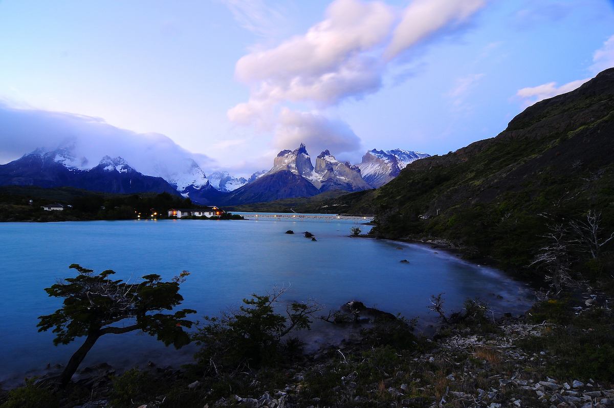 Photo: Francisco Negroni
Challenges for the future
It is internationally renowned, and, without doubt, this national park has become one of the great icons of Patagonia, becoming the eighth wonder of the world in 2013 after competing with 330 other destinations of the world in a global online vote.
Unfortunately, its popularity has brought environmental consequences, including at times an overload of tourists that surpasses the sustainable capacity of the park, eroded trails, pollution and, most seriously, two large-scale wildfires (2005 and 2011) directly linked to tourists and insufficient park policies. And while every year there are record numbers of visitors, the same cannot be said about the investment, which is still low in comparison and as such there is neither the level of infrastructure nor staff necessary to manage so many tourists.
But it’s not all bad news, some advances the park has made since 2016 include: an obligatory reservation system for staying overnight at campsites and mountain huts; cameras to monitor and prevent forest fires; a significant reforestation plan; and improved enforcement of rules inside the park. In recent years, several tourists have even been expelled from the park for not complying with rules stated when entering the park, in particular measures prohibiting “any kind of fire, in any situation and in any place.”
Chile’s government has also recently committed to increasing investment in its parks with the creation of the Route of Parks in Patagonia last year, a scenic route encompassing 17 national parks located between the city of Puerto Montt in Chile’s Lake District all the way to Cape Horn at the southernmost tip of the South American continent. The initiative is one more step in the history of the conservation of these lands for future generations.
* This article is based in part on research and writing Evelyn Pfeiffer did for the book "El Paraiso de la Patagonia," published by Chile's national park service in 2009 to help commemorate the 50th anniversary of Torres del Paine National Park.


.gif)


